FORGOT YOUR DETAILS?

Foraging and Wild Food

How to use Magic Map

20th May 2021

The Forager's Law

Something that we always talk about on our foraging courses is the law. This isn’t in a general “don’t do naughty things or the police will throw you in jail”, but a well researched overview of the various laws which apply when you are out collecting plants and funghi. “Various laws” because there is no one law to rule us all when it comes to foraging, but several relvant laws of which to be aware. Aside from the well-known factor of protected species, we talk about the less well know protected areas of land, which can even prohibit the landowner from cutting back branches or digging a hole on their own patch without the correct permissions.

Areas of land or water can be designated as Sites of Special Scientific Interest (SSSIs) or Special Areas of Conservation (SACs) or even as Special Protection Areas (SPAs). As foragers we are mostly concerned with the first two of these. Most designations have been in place for many years, but more are being selected and nominated for protected status. The interesting thing about SSSIs and SACs is that they could be designated for any number of reasons, be they animal, vegetable or mineral. However, the overall designation means that they are afforded the same protections and are covered by the same laws. These laws mean that foraging within the boundaries of any of these sites is not legal, unless you have a licence from the relevant environmental government authority (Natural England, Natural Resources Wales or Nature Scot).

Spot the Signposts

The thing is, these special areas are rarely signposted, or marked out in any way on the ground. There is no big stone with a plaque to announce that you have entered a special area. At some country parks or nature reserves there may be information boards about the site which include mention of designated areas within or overlapping the boundary, but they don’t usually show you exactly where the line of protection lies. Designated sites are not confined to areas such as nature reserves and country parks either, in fact the majority lie on privately owned property. The usual access laws regarding footpaths etc. apply to designated sites, perhaps with special requests at certain times of year to protect the wildlife which resides there. However, the list of potentially damaging operations which must not be undertaken without a licence more often than not includes ‘removal of plants’. This applies to any part of a plant, even ‘the four F’s’ and is applicable whether you are collecting for yourself or to sell.

So, how does one find out if your usual salad picking spot or bountiful secret sloe sanctuary lies within an area protected for nature? Here at Original Outdoors we consult the government website that is Magic Map, an interactive online map with a seemingly endless number of layers which you can switch on and off as is appropriate to you. It’s relatively intuitive to use, you can zoom in to the exact location which you are interested in and if there is a designated site it is clearly marked with a coloured, hatched area and a name next to it. To take it one step further you can search the internet for the site name and designation and find information on why it is designated.

Using Magic Map

To use Magic Map, simply go to their website. It will display a map of the UK and a list on the left hand side. This is a list of different layers, for our purposes select the little “+” next to “Designations” and then again next to “Land-based designations” and then “Statutory”.

Image copyright DEFRA

From this you can select SSSI or SAC layers based on location. After selecting the layers you are interested in, you can zoom in on the area of the country in which you are interested, be it an area which you are visiting or somewhere that you already go to forage. The sites will show up as dots on the map at first but as you zoom in, they become defined shapes overlaying an Ordnance Survey map layer with a tracking grid reference in the bottom left of the screen. This is particularly handy if the boundary doesn’t line up with another feature like a fence or river or woodland edge.

Image copyright DEFRA

Interpreting the Results

Magic Map allows you to draw a polygon and perform a site check which will then list any designations within that area. It will also perform a point check and has tools so that you can draw or write on a map and print it off. Just be sure that you read the terms and conditions and check about copyright law associated with sharing digital or physical maps with others.

Magic Map is a fantastic tool, useful to all sorts of people and I expect underused when it comes to foraging. The best thing that you can do to familiarise with it is simply to visit the site and have a play with the different features. It can help you to plot routes, find out what areas you pass through and where you stand legally with your foraging.

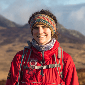
With over a decade of experience working outside in the UK doing everything from dry stone walling to tree planting and carrying out wildlife surveys. Amy is our resident ecologist and wild food enthusiast, and also works as a consultant for various brands and wildlife organisations. Amy lives in North Wales.

A Life more Wild.

A Life More Wild is the philosophy which underpins everything we do.

It encompasses practical skills, personal development, community learning and a journey to live more intentionally.

THE ACADEMY

EXCLUSIVE CONTENT AND TRAINING

.

TOP