FORGOT YOUR DETAILS?

CREATE ACCOUNT

Mapping-Scales-UK-16-scaled
Outdoor Skills

How to choose the right map scale – 25k, 40k or 50k?

25th January 2019

Choosing the right mapping scale for hiking and walking in the UK

Anyone who as attended one of our North Wales navigation courses will be familiar with one of the tabletop sessions dealing with the various maps available for the UK. We run these sessions during the brief indoor part of the courses (usually accompanied by a cup of something warm and caffeinated) because it is not quite as straightforward as it might appear to be.

I am of the confident assertion that in the UK we have probably the best topographical mapping in the world, especially for hillwalking, mountaineering and outdoor activities. There can occasionally be a bit TOO much choice though, and choosing the correct map scale (and publisher) for the area you are about to go adventuring in needs a little careful thought.

This post should cover the basics of choosing a map scale for the UK.

Mapping Scale Options for the UK

There are two mapping scales that tend to be used for walking, mountaineering and other human-powered travels across the landscape in the UK – 1:25,000 and 1:50,000 scales. The main producer of topographical maps for outdoor activities (and everything else) is the Ordnance Survey (OS), and the 1:25,000 (Explorer) and 1:50,000 (Landranger) scales are readily available at outdoor shops, online and local retailers. They also produce various digital mapping products, as well as an online mapping service and smartphone app.

Harvey Maps, founded in 1977, produce maps that cover the popular hillwalking and mountaineering areas of the UK, plus some of the designated long-distance trails and other areas. They also produce maps for cyclists, fell runners and orienteering.
Their maps differ from OS maps in that they are produced at the slightly less common 1:40,000 scale, sometimes referred to as the ‘magic scale’ as it has enough detail to navigate by whilst also covering a wide area. They also produce a 1:25,000 series called Superwalker.

1:25,000 Scale (OS Explorer Maps Series and Harvey Superwalker)

At this scale 4cm on the map is equal to 1km and public rights of way, fence/wall lines and even individual crags and large boulders. This scale is about as detailed as you would want it to be for hiking and mountain walking, but it can show TOO much detail for some users. More on that below!

1:50,000 Scale (OS Landranger Maps Series)

This is the ‘next’ level of mapping up from 1:25,000 scale. At this level 2cm is equal to 1km, and in one sense you can fit four times the area of mapped land into the same space on the paper. Roads, major paths/trails and watercourses are shown and the contour interval is always 10m.

1:40,000 Scale (Harvey Maps various)

This is the in-between scale that some people favour because it balances detail with coverage. At this scale 2.5cm is equal to 1km, and the contour interval is at 15m. Harvey Maps also include ‘extra’ contour lines that show complex terrain that would otherwise be missed by the 15m contour interval. Some fencelines and paths are shown, but not all. The features that are chosen to be included on the map are biased towards hillwalkers and mountaineers, and extra shading is included to show ‘bands’ of relative altitude.

How far do you need to see?

The obvious factor to consider when choosing a map scale is how much of an area you need to be able to see on one map sheet versus how much detail you need.

If you need to be able to see the information for a dozen kilometres or more at a time then you will need a map with a relatively small scale of 1:100,000 or smaller. This will give you a good overview of the large features of an area, but won’t show the minor details. You can distinguish between roads and the major rivers, but won’t be able to see the individual folds of a hillside or where isolated building are.

If you want to have some fine detail, but still have an overview of several kilometres at a time then something like a 1:50,000 scale map will be more appropriate. This will show contours, paths, major crags and some significant buildings but will also allow you to quickly scan across the next few hours of walking route without having to unfold/refold the map.

For finer detail and only looking at a small area at a time then a 1:25,000 scale map is about as detailed as you would want it to be. This will show individual boundary lines, smaller crags and rockfaces and areas of different ground vegetation and even bogs. It will also have A LOT of information and you may need to mentally ‘blank out’ the bits you don’t need to pay attention to so that you can focus on the relevant parts.

In the three photographs below I have placed the same compass on roughly the same line running west-east just north of Fort William. It shows the balance between having enough detail to navigate by and being able to see a larger area in one glance:

Contour Intervals

The ‘contour interval’ is the vertical gap between marked contour lines on the map. If a contour line reads ’90m’ and then the next one up the hill reads ’95m’ then the contour interval is 5m, and so on.

This matters when choosing a map scale as the contour lines shown can both give the navigator a lot of detail to navigate from BUT also provide too much detail and make things confusing. With that said, contour lines only show a broad trend in the shape of a landscape. Objects and lumps on the hillside that are smaller than the contour interval may not be shown. 5m is the height of a bungalow, which would be a significant obstacle to navigate around but it would not appear on a 10m-interval map.

For Ordnance Survey maps the contour interval of 1:50,000 scale is every 10m (vertically), and it can be either 5m OR 10m for 1:25,000 scale maps. For Harvey maps the contour interval is every 15m.

On the 1:25,000 OS maps that variance between it being either 5m or 10m for the vertical contour interval can be a little confusing – the deciding factor seems to be just how ‘lumpy’ the area covered is. If it’s more mountainous then the contour interval is more likely to be 10m, and for flatter, more gently rolling areas then it is more likely to be 5m.

The graphic below has two photos, each of the same ‘grid square’ (just west of Ruthin in Denbighshire). However, one photo (the left one) is from Explorer sheet 265 Clwydian Range and the other (right) is from sheet 264 Vale of Clwyd. Both are the same scale (1:25,000) and they overlap for a few kilometres in the are to the west of Ruthin and Denbigh. However – as you can see – there are two completely different contour intervals for that area, depending on which map sheet you are looking at.

How much detail do you need?

For any mapmaker there is a balance that needs to be struck between presenting information in a clear and relevant way and ensuring that the map is still usable. This isn’t just about scale, but also about choice of colour and symbols used to represent real-world features.

On the graphic below you can see the same area of the eastern flanks of Snowdon, particularly the area between Llyn Lydaw and Glaslyn.

The difference between the OS 1:50,000 and 1:25,000 mapping (left hand) is subtle, as the contour interval is the same and the colours are broadly similar. The most obvious difference is that the crags and rocky outcrop locations are more accurately mapped on the 1:25,000, and it would be possible to navigate from buttress to buttress.

On the right there are two versions of Harvey 1:40,000 scale mapping, the top one produced by the British Mountaineering Council (BMC) and the lower the Harvey standard mapping for the same area. Shading to denote bands of altitude/height really makes the ‘shape’ of the landscape jump out. It’s very clear on the upper (BMC) map, but it’s still quite apparent on the lower one.

Do fences and boundary lines matter?

One significant difference between OS 1:25,000 and 1:50,000 mapping is the presence or absence of marked fencing and wall locations on the map. As these are static and almost always long-standing features of the landscape they CAN make excellent navigation aids. I have navigated to and from fence junctions numerous times, and they make great features for handrailing along when navigating between waypoints.

The three photos here show the same area of the north-eastern end of Llyn Gwynant and the hillside above. On the 1:50,000 OS map there are some significant feature but no fence or boundary lines marked. On the 1:25,000 Os map and the 1:40,000 Harvey map the fence running uphill from the river are clearly marked – although much more accurately on the 1:25,000 map. If I was navigating using the 1:40,000 map I could say that “there is a fence somewhere around here”, but if I was using the 1:25,000 map I could identify the fence and follow it uphill or downhill with confidence of my position at all times.

More detail than 1:25,000?

There are other mapping scales on the market, but they are only readily available for certain areas of the UK, or through specialist suppliers. Harvey Maps include ultra-detailed 1:12,500 scale sections of difficult mountain areas on the reverse side of some of their 1:25,000 scale Superwalker series.

Below are three images of maps of the Cuillin range on Skye; the left one being the OS 1:25,000 map, the middle the Harvey Maps 1:25,000 and the right a cropped and zoomed shot of the relevant area of the 1:12,500 section. The three sections show the same terrain, but the 1:12,500 version is much easier to read. This can be critical when trying to navigate in poor visibility in very complex terrain, especially in places where the rocks are mildly magnetic and make compasses unreliable – like Skye!

So, 1:25,000 is the best because of the detail?

Maaaaaaaybe. I use Ordnance Survey 1:25,000 mapping for about 95% of the work I do in the UK, but there are times when I will use 1:50,000 – and that’s often in the winter.

Having extra detail and lots of features to navigate between is great for micro-navigation, but if half of those features are buried beneath a metre or two of snow then they aren’t much use – in fact, they are more of a hinderance. So when there is a thick blanket of snow on the ground I will often choose a 1:50,000 map as I am able to see the overall shape of the landscape. A blanket of snow will round off the sharp edges of a mountain and smooth out the crevices – all that is left is a broad curve, which is exactly what you see on a 1:50,000 map.

A matter of personal choice

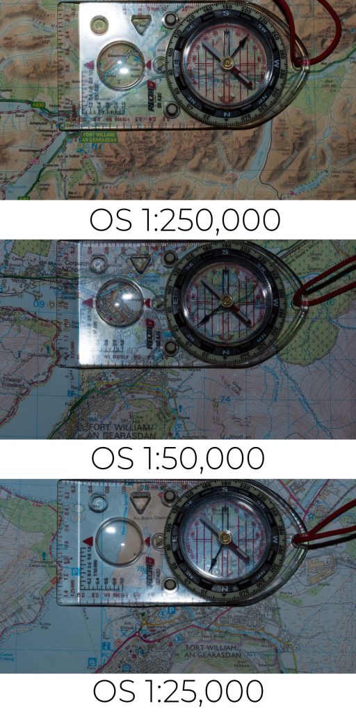
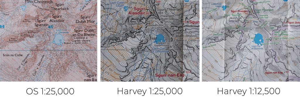
In the vast majority of cases it won’t matter TOO much if you are carrying a 1;50,000 or a 1:25,000 map for the area – as long as it is up to date, waterproofed somehow and YOU KNOW HOW TO USE IT! 🙂

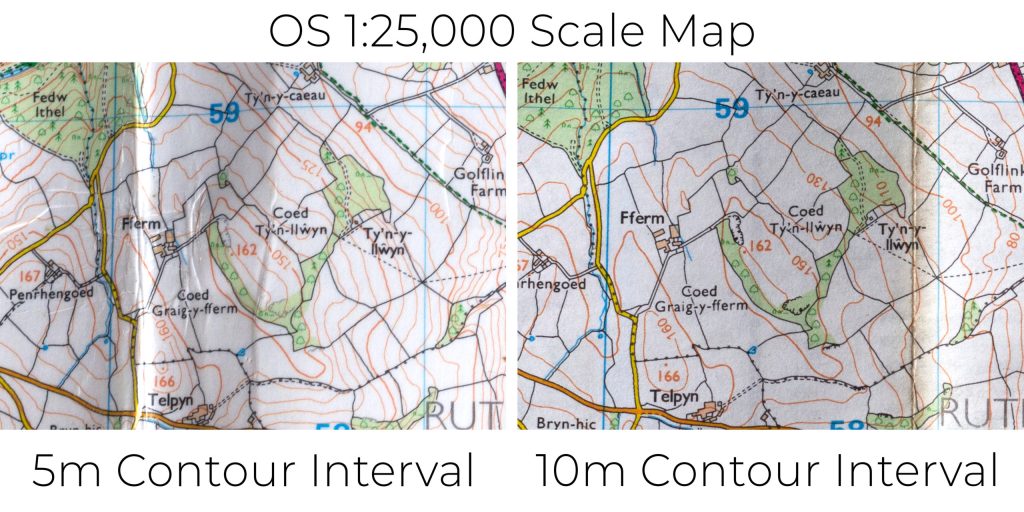
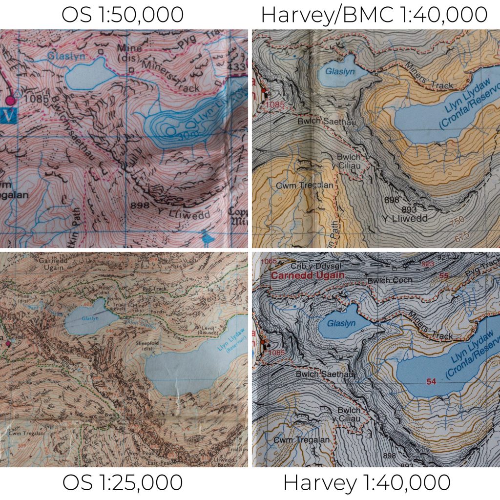
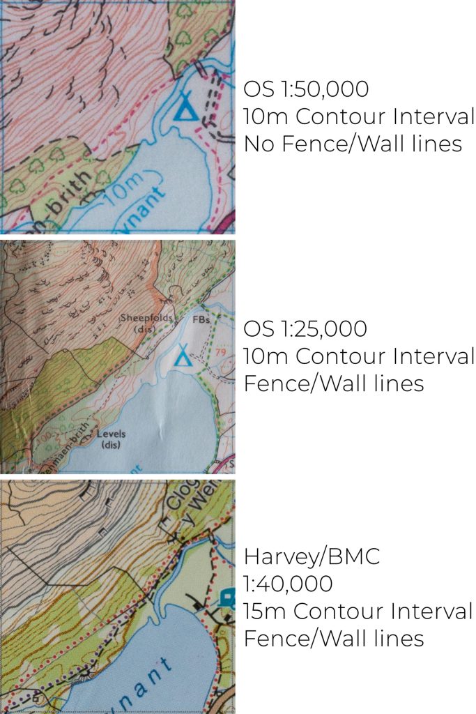
It matters most that the map shows enough detail for what you are planning to do, and that you know how to read it. If you feel that a 1:50,000 or 1:40,000 scale map has enough detail for the activity you are doing then it will be fine. If however you want to know the exact location of field edges or the a wiggle in a contour line then a 1:25,000 scale map will be more appropriate.

I use a mixture, using 1:25,000 for navigating when out on the ground, 1:50,000 for planning multi-day routes and mountain biking and other scales when necessary. I tend to use OS maps rather than Harvey Maps, but I think that is because I first learned how to read a map with a battered OS map, deep in the countryside and stumbling through muddy fields on Air Cadet camp weekends as a teenager. I know, and work with, quite a few instructors and outdoor professionals who will only use a 1:50,000 map, and it is expected that you be competent navigating off all of the common mapping scales if you undertake your Mountain Leader assessment or similar.

A Mountain Leader with over a decade of experience across the UK and overseas, Richard is our Lead Instructor and a partner in Original Outdoors. He is a specialist in temperate wilderness skills and the wild foods of the British Isles, and also works as a consultant for various brands and organisations. Richard lives in North Wales.

A Life more Wild.

A Life More Wild is the philosophy which underpins everything we do.

It encompasses practical skills, personal development, community learning and a journey to live more intentionally.

THE ACADEMY

EXCLUSIVE CONTENT AND TRAINING

.

Snowdrop

Can I dig up Snowdrops?

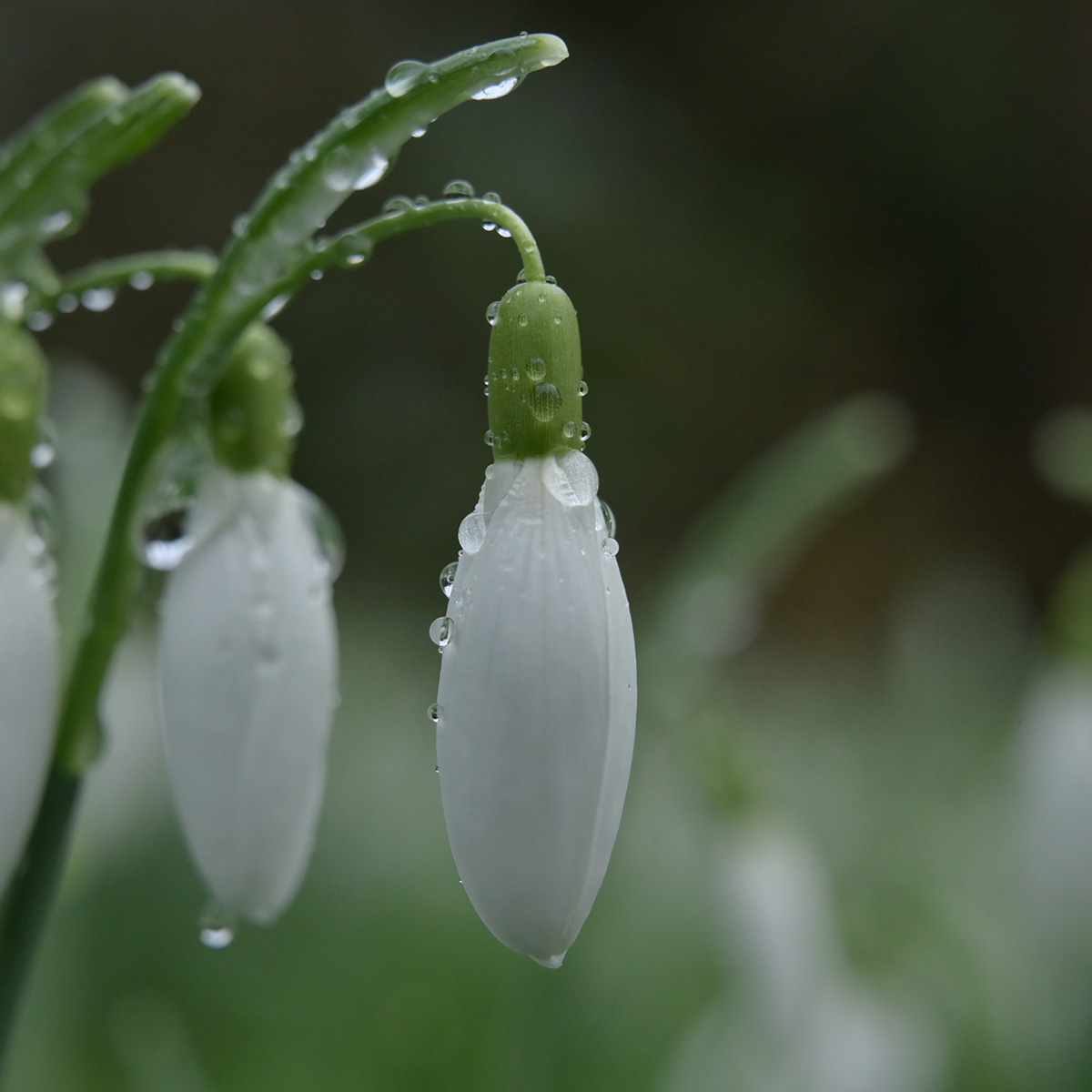
If you plan on transplanting snowdrops from one location into another, the best time of year to do this is as the leaves are fading…

Snowdrop flower

Can I pick Snowdrops?

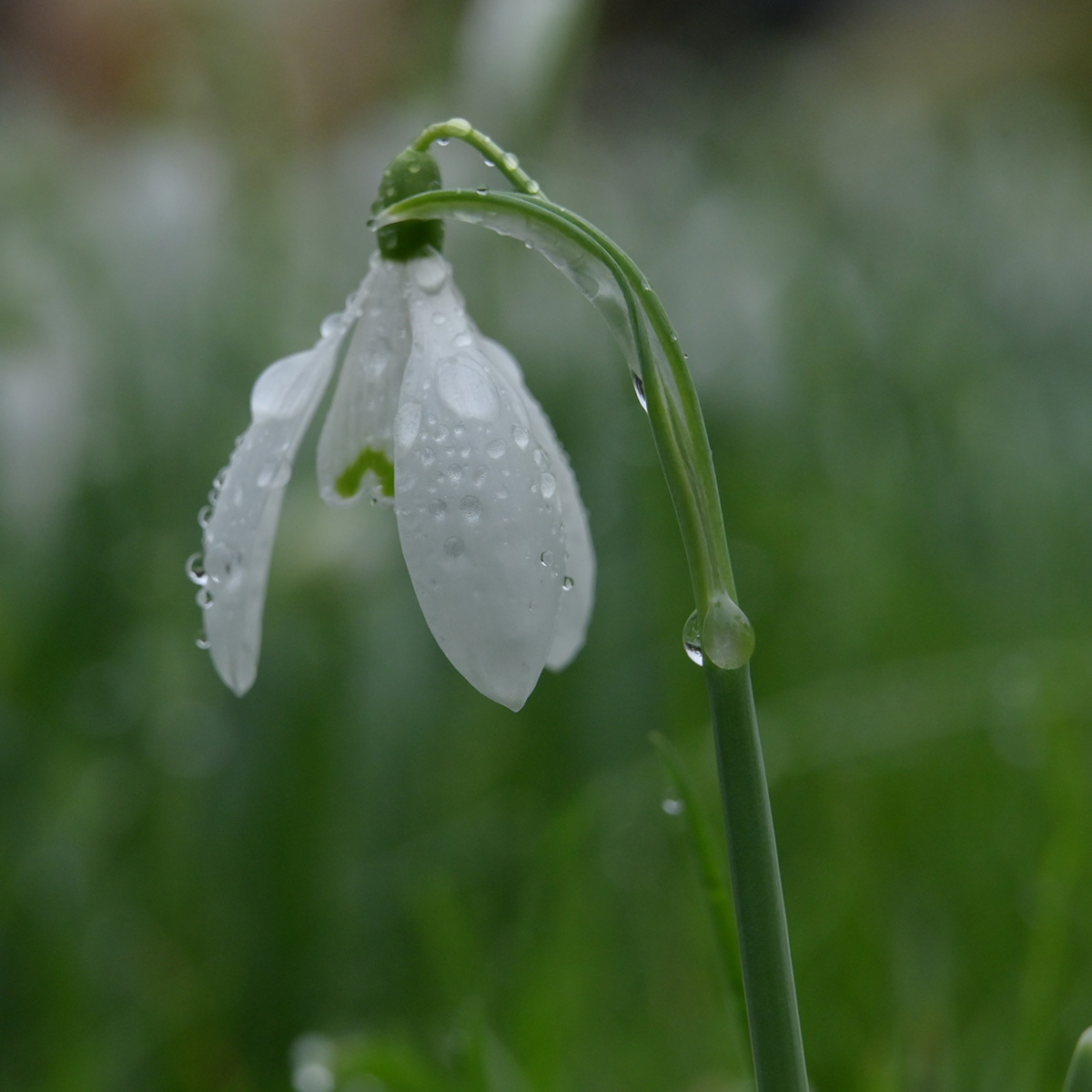
Snowdrops are a beautiful, with their nodding white bell shaped flowers which secret away the intricately green lined centre underneath.

TOP